
01 THE QUESTION THIS PIECE ANSWERS
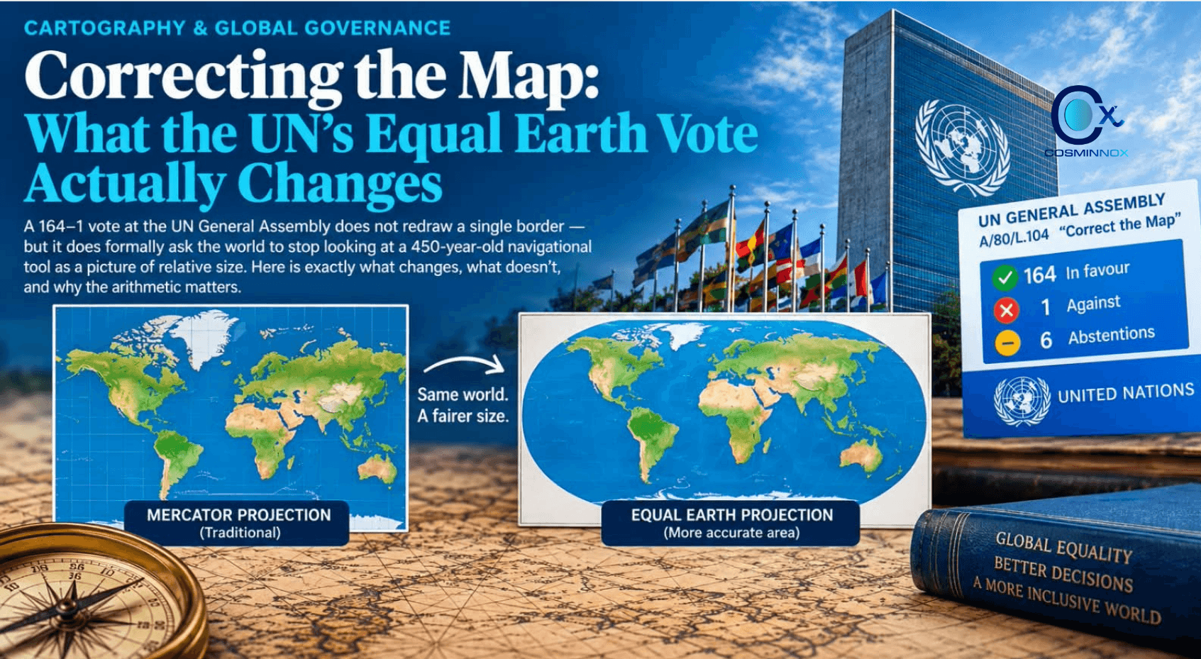
On 4 September 2026, the UN General Assembly adopted resolution A/80/L.104, “Correct the Map,” encouraging wider use of equal-area projections — chiefly the 2018 Equal Earth projection — in place of the 1569 Mercator projection wherever the comparative size of regions matters. The question worth answering precisely, not rhetorically, is: what does this resolution bind anyone to do, and what does it merely recommend?
02 THE VOTE, IN FULL
Metric | Result |
Resolution | A/80/L.104, “Correct the Map” |
Sponsor | Togo, on behalf of the African Group; co-sponsored by the Bahamas |
Vote | 164 in favour – 1 against – 6 abstentions |
Against | United States |
Abstained | Estonia, Georgia, Lithuania, Moldova, Serbia, Ukraine |
India's position | Voted in favour; explanation of vote clarified this does not endorse a specific map or boundary depiction |
Date adopted | 4 September 2026 (80th UNGA session) |
Source: UN Meetings Coverage, GA/12779 (press.un.org), 4 September 2026.
03 FULL VOTE BREAKDOWN
Vote | Countries |
Against (1) | United States |
Abstained (6) | Estonia, Georgia, Lithuania, Moldova, Serbia, Ukraine |
In favour (164) | The remaining voting UN member states, including India, all African Union members, the UK, France, Germany, Japan, China, Brazil and most of Latin America, Asia and the Pacific. France separately announced it would stop using Mercator in its own materials. |
Source: UN Meetings Coverage, GA/12779; Reuters and Deccan Chronicle reporting on the vote, September 2026. The UN does not publish a full 164-country roll call in its summary coverage — only the against/abstain lists are individually named.
04 WHY THE US WAS THE SOLE VOTE AGAINST
Washington's objection was not about the underlying cartography — the US delegation did not dispute that Mercator distorts area. Its case was that the resolution was a political project dressed up as a technical correction, and that the General Assembly was spending its time on 16th-century map projections and questions of historical redress instead of pressing matters of international peace and prosperity. The US representative argued such resolutions erode the institution's credibility and urged other delegations to vote it down, before casting the sole “no.”
05 A LONGER HISTORY THAN ONE VOTE
The 2026 UN resolution is the latest turn in a debate that runs back more than half a century — not a sudden 2026 invention. The table below traces the line from Mercator's original 1569 design through Arno Peters' 1970s equal-area challenge to this year's vote.
Year | Development |
1569 | Gerardus Mercator publishes the projection, built to preserve compass bearings for maritime navigation. |
1973–74 | German historian Arno Peters popularises an equal-area alternative (built on a projection James Gall had described in 1855), promoting it as a fairer, less Eurocentric world map. |
1986 | The American Cartographic Association publishes a comparison of world map projections and coins the name “Gall–Peters projection.” |
2017 | Boston Public Schools becomes the first US public school district to formally adopt the Gall–Peters projection in classrooms. |
2018 | Cartographers Bojan Šavrič, Tom Patterson and Bernhard Jenny publish the Equal Earth projection, designed to preserve area while keeping a more naturalistic, globe-like shape than Gall–Peters. |
Aug 2025 | Advocacy groups Africa No Filter and Speak Up Africa launch the “Correct the Map” campaign; the African Union formally endorses it. |
Mar 2026 | The African Union formally adopts the Equal Earth projection for its own use. |
Apr 2026 | Togo, on behalf of the African Group, formally asks UN member states to follow suit. |
4 Sep 2026 | UN General Assembly adopts A/80/L.104, “Correct the Map,” 164–1 with 6 abstentions. |
Source: American Cartographic Association records; Boston Public Schools coverage (2017); Equal Earth project documentation (2018); Africa No Filter / Speak Up Africa campaign materials; UN Meetings Coverage GA/12779.
06 WHY MERCATOR DISTORTS — AND BY HOW MUCH
Mercator's 1569 design solved a navigation problem: straight lines on the map hold a constant compass bearing, which made it indispensable for sailors. The mathematical cost is that landmasses are stretched in proportion to their distance from the equator. The table and chart below show the gap between true land area and how that same land reads on a standard Mercator map.
Landmass | True area (mn km²) | Looks on Mercator as |
Africa | 30.37 | ≈ same size as Greenland |
Greenland | 2.17 | ≈ same size as Africa (14x smaller in reality) |
Russia | 17.1 | Visually larger than Africa, though Africa is ≈1.8x its size |
Brazil | 8.5 | ≈ same size as Alaska (5x smaller in reality) |
Alaska | 1.72 | ≈ same size as Brazil |
Source: UN General Assembly press coverage (GA/12779); Reuters and Al Jazeera reporting on the resolution, September 2026. Figures for true land area are standard geographic references.
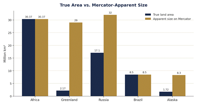
Fig. 1 — True area vs. how the same landmass reads on a Mercator map (million km²)
07 WHAT THE RESOLUTION CHANGES
Four concrete things follow from adoption: (1) it formally records near-unanimous UN member-state support for equal-area projections in educational and public-communication contexts; (2) it creates institutional cover for ministries of education, publishers and cartographic agencies that choose to switch; (3) it sets up a follow-on convening — Togo, with UNESCO and the African Union, is understood to be organising a meeting in Lomé early next year with technology companies, reportedly including Google Maps, to discuss adoption pathways; and (4) it gives the African Union's March 2026 adoption of Equal Earth a UN-level echo.
08 WHAT IT DOES NOT CHANGE
The resolution is a General Assembly recommendation under UN Charter Article 10, not a treaty. It creates no legal obligation on any state, school system, or company to drop Mercator. It does not touch international boundaries, disputed territories, or place-name disputes — India's Ministry of External Affairs explicitly noted in its explanation of vote that the resolution does not endorse any specific depiction of national boundaries. Nor does it restrict Mercator's continued, uncontested use for its original purpose: maritime and aeronautical navigation, where preserving compass bearings still matters more than preserving area.
09 COUNTER-EVIDENCE AND DISSENT
Beyond the US objection covered above, some legal commentary has flagged a separate risk: that a non-binding cartographic resolution could still be invoked rhetorically in unrelated boundary disputes, even though the text explicitly disclaims any bearing on international boundaries or place-name questions — a risk worth tracking rather than dismissing, and part of why India's explanation of vote was so precise about what the resolution does not do.
10 WHAT THE EVIDENCE SUPPORTS
The vote establishes political consensus, not legal change. What happens next — whether textbooks, atlases and mapping platforms actually switch — depends entirely on decisions individual governments, publishers and companies make on their own, informed but not compelled by this resolution. Whether Equal Earth becomes the new classroom default or remains a UN talking point is not something this vote itself resolves.